What to expect if El Niño transitions to La Niña in 2016?
June 8 2016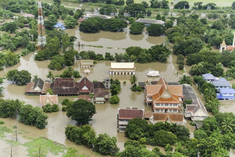
About one year ago in June 2015, there was wide concern of a strong El Niño that would eventually become one of the strongest in history. Since then, we have witnessed severe droughts in Korea and Philippines, heatwaves in India and Pakistan, huge forest fires in Indonesia and multiple heavy rainstorms in southern China, and other severe weather conditions in the Asia Pacific region during the past 10 months. The 2015 tropical cyclone season also brought one of the most active period on record for the North Pacific Basin, with several impactful landfalls affecting interests in the West Pacific. Now, in May 2016, it is clear that this El Niño event is weakening. According to the National Oceanic and Atmospheric Administration (NOAA), the current El Niño has a good chance of transitioning to the La Niña phase, perhaps within six months.
 What are EI Niño and La Niña?
These are phases of the EI Niño Southern Oscillation (ENSO). The warm phase or “EI Niño” is characterised by sea-surface temperatures in the tropical East Pacific that are above normal. The “La Niña” phase is characterised by the opposite, with sea-surface temperatures in the tropical East Pacific that are below average. Both of these phases have distinct effects on weather and climate on a worldwide basis. ENSO is monitored by indices such as the Southern Oscillation Index (SOI) and the Oceanic Niño Index (ONI).
Figure 1 indicates how ENSO events are classified based on the ONI. The sustained negative values of the ONI below −0.5°C indicate a La Niña event, while sustained positive values above +0.5°C indicate an El Niño event. To use a rough analogy, ENSO may be compared to bull and bear stock markets. The two types of market condition transition to each other periodically, as do El Niño and La Niña. The time period for a full ENSO cycle is generally three to six years.
According to the average of an ensemble of dynamic models, it is projected that the three-month average of the ONI will drop below -0.5°C, indicating La Nina conditions.

If a La Niña is in store, what should we expect?
While there are countless possibilities in any season, this article focuses on the more likely scenarios.
It is known that La Niña is associated with wetter conditions over South-East Asia and northern Australia. Cold sea surface temperatures in the equatorial central Pacific favour formation of rain-producing clouds that bring wet conditions in the west, over India, Indonesia, Malaysia and northern Australia, as illustrated in Figure 3.
 In contrast, during El Niño, a shift in circulation patterns over the tropical Pacific Ocean brings reduced rainfall over Indonesia, Malaysia and Australia. At the same time, an associated low pressure over the Indian Ocean typically brings dry air from Central Asia, with abnormally dry conditions to India during the monsoon season.
Guy Carpenter classified each historical year from 1960 to 2015 as La Niña, El Niño or Neutral using SOI data from NOAA and mapped disaster records from the International Disaster Database. Based on this classification, the frequency of droughts and wildfires in La Niña years is lower than neutral years and significantly lower than that in El Niño years.
Between 1960 and 2015, among all years identified with severe droughts in India, only 18% occurred in La Niña years while 55% occurred in El Niño years. In Australia, from 1990 to 2015 a total of 24 major wildfire events have occurred and only three were in La Niña years while nine were in neutral years and 12 in El Niño years. The wildfires occurred in the strong El Niño year of 2015. A similar situation is observed in Malaysia, Indonesia, Philippines, Vietnam, Cambodia, Thailand, Laos and Fiji. Collectively, between 1965 and 2012, annual drought frequency is 0.7 in these countries in La Niña years, lower than the 1.05 of neutral years, and 1.27 of El Niño years. Although the analysis might be biased by limited data, it presents a clear pattern that drought and wildfire are generally suppressed in La Niña years.
On the other hand, increased rainfall in La Nina years should result in more flooding. The combined Malaysia, Indonesia, Philippines, Vietnam, Cambodia, Thailand, Laos and Fiji annual flood frequency is 9.4 in La Niña years, higher than 7.3 of neutral years, and 7.9 of El Niño years. Based on loss data from the Insurance Council Australia, the annual loss during La Niña periods is approximately double the annual losses during Neutral and El Niño periods. This is largely due to increased losses from tropical cyclone and flood events.
 La Niña may also impact tropical cyclone activities in the broader Asia-Pacific region. In a La Niña year, land-falling tropical cyclones in Japan are likely to be suppressed due to the characteristic track pattern induced by La Niña. In general, the tropical cyclones tend to form more westward, track towards China and are less likely to recurve back towards Japan.
Compared to Japan, La Niña’s impact on land-falling tropical cyclones is less obvious at low-latitude typhoon-prone Asian regions, such as southern China, Taiwan, Vietnam, etc. It was commonly assumed that land-falling tropical cyclones were enhanced in La Niña years in the above areas. However, this theory is significantly affected by the inactive tropical cyclone activity over the whole West North Pacific during the past two decades, when the mean annual number of tropical cyclones in La Niña years decreased from 27.8 during 1960-1997 to 18.7 during 1998-2015. As a result, the relation between land- falling tropical cyclones in the areas and La Niña becomes weak and hard to explain. This also demonstrates difficulties in understanding La Niña and its regional impacts.
In summary, based on historical experience, drought and wildfire conditions are likely to be suppressed in South-East Asia and Australia as a result of increased rainfall. However, the increased rainfall results in a higher likelihood of flooding in the above regions. In terms of tropical cyclone activity, the number of landfalls is likely to be suppressed in Japan because of the genesis location shift related to La Niña. However, in lower- latitude Asian regions, the relation between La Niña and tropical cyclones is more complicated and less obvious.
Guy Carpenter
By Hang Gao, PhD, Vice President, Guy Carpenter Beijing, Xuerong Qin, PhD, Catastrophe Analyst, Guy Carpenter Sydney and James Waller, PhD, Research Meteorologist for GC Analytics, Guy Carpenter Philadelphiaƒ
-
PartnerRe | Dementia the protection gap insurers can no longer ignore
Unlike acute illnesses, dementia creates a long tail of financial need and its impact extends well beyond patients.
-
Sedgwick | Investing in people is shaping the future of loss adjusting in Asia
Sedgwick Asia says it is ready to meet the evolving challenges of Asia’s dynamic insurance markets.
-
PartnerRe | Understanding ageing in APAC: why perception, planning and protection don’t always align
Ageing is shaping finances, family dynamics and insurance needs of the caregiving ecosystem, but current product propositions and underwriting frameworks are not keeping pace with protection needs, finds PartnerRe survey.
-
BHSI | D&O in Asia in 2026: navigating geopolitics, insolvencies, and digital crackdowns without breaking the bank
A soft market presents organisations with opportunities to strengthen resilience, although the abundance of capacity is unlikely to persist.